The Right Trail: Local knowledge makes Palestine navigational maps more in-depth
Published 4:47 pm Thursday, June 30, 2022
- Detailed navigational maps make boating through areas on Lake Palestine that look safe on the surface, but are dangerous below the waterline, safer.
I am not going to say Tom Mayne has been on Lake Palestine since the Caddo Indians lived along the Neches River, but he has been around a while.
So if someone is going to know just how dangerous the lake remains after 50 year and comes out with an onboard navigation map to help boaters stay safe, he is a good option.
“It is every bit as dangerous as it has ever been, or worse,” Mayne said of the treacherous conditions on Palestine.
During construction, a good portion of the timber was left standing, especially north of the Texas 155 bridge. However, most fishermen and boaters today were not even born when the trees broke off just below the water line. They know there is timber in there, but most probably do not know how much or where.
“Everyone knows the north end is dangerous, but from The Villages south they can’t see it until it is a foot low. At two feet it is better because they are exposed,” Mayne said.
He added that lake-wide the timber tops sit about a foot below the surface making them like a magnet for hulls and lower units.
The idea of charting boat lanes came to Mayne about five years ago. A tournament fisherman and guide on the lake, the thought was more boating safety than monetary reward.
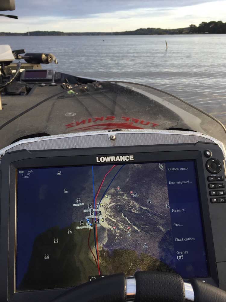
While modern GPS units offer some navigational maps, they are more overviews than complete information. Mayne’s version uses information from a variety of sources including a Lowrance map from 1985 when the trees were still visible, historical photos of the lake at low water levels, information from other fishermen, and, of course, his own years-long background fishing the lake.
He recently came out with an updated version of Lake Palestine.
“I added colored lanes on the north end so you have a good idea of what to be aware of. If you have a red trail, you can idle along it at full pool,” Mayne said.
In his earlier version, Mayne left off much of the north end of the lake because it is simply too dangerous to run at any speed above idle. This time he added lanes up the river, Kickapoo and Flat creeks, as well as trails in Old Folks and Cades areas, and Highsaw/Ledbetter on the south end. It also adds additional timber area and equally dangerous sandbars.
The lanes are marked in one of three colors based on their danger level. However, do not look for any green lanes to run wide open.
“I was hesitant to do run lanes,” Mayne said.
The maps run at real time, however, the limitation is the driver’s ability to control the boat.
“No one can drive a boat dead-on a lane. It is impossible,” said Mayne, as a warning not to use manufacturer maps. “My maps import a series of waypoints and trails. These maps will overlay any existing base map such as Navionics or Lakemaster, however, I do not advise running lanes in timber based off any base map.”
Even his maps have a 100-foot cushion from The Villages north, and for that reason he recommends staying as close to the lane as possible at full pool.
He said what is telling about the map is to have clients on the lake fishing and using the map show them what looks like pristine waters on the surface is a forest below the water line.
Because of proprietary technology used by different manufacturers, Mayne has had to develop different cards for different brands. Even then, his maps do not work on every mapping unit. His two Lake Palestine versions, the new Pro and original Guide, do work on Lowrance, Humminbird and Garmin.
While it would seem most anglers would already have downloaded the lanes, the demand continues to grow. They were popular with Major League Fishing pros this spring who were forced to the north end for their General Tire Heavy Hitters tournament in early April. They are also in demand from mentors working with students competing in Texas High School Bass Association events on the lake, not to mention new owners with a boat investment that can quickly run $50,000 and more.
The Pro Lane series is $79.95 for a card or $60 for a digital download sent by email. The Guide series is $39.95 or $35.
Mayne has also created maps for Tawakoni that run on Lowrance, Humminbird and Garmin, as well as maps for Martin Creek and Bob Sandlin that run on Lowrance and Humminbird Helix and Legacy units. Those maps cost $39.95 or $35.
For more information on the navigational maps, go online to lakepalestinefishingguide.com or contact Mayne at 903-279-9083 or by email at tmayne73@yahoo.com.


-
eEdition
-
-
