Beryl produced record number of East Texas tornado warnings but minimal damage
Published 7:30 pm Tuesday, July 9, 2024
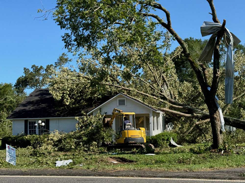
- At least one confirmed tornado hit Bethany on Monday, July 8, 2024 in the wake of Hurricane Beryl's remnants, the Panola County Sheriff's Office said. (Meredith Shamburger/Panola Watchman)
Tropical Storm Beryl spawned a record number of tornado warnings throughout East Texas on Monday, saturating the region with heavy rainfall, damaging property and leaving tens of thousands without power.
But despite the high winds and heavy rains, emergency management officials throughout the region said damage and flooding were minimal and less severe than earlier spring storms that hammered the region.
Beryl, which made landfall Monday morning along the Texas coast as a Category 1 hurricane, weakened as it traveled northeast but spurred an extensive outbreak of severe weather through the Ark-La-Tex region.
The National Weather Service in Shreveport issued 67 tornado warnings between 12:19 p.m. and 8:20 p.m. Monday. That’s the highest number of tornado warnings ever issued by a National Weather Service office during the month of July, meteorologist Ryan Knapp said. It’s also the highest number of warnings issued by the weather service in Shreveport during a single-day event. The previous record was 36 set Dec. 27, 2015.
Meteorologists issued 111 tornado warnings throughout Beryl’s path across Texas, Louisiana and Arkansas, Knapp said.
The weather service hadn’t confirmed tornadoes as of 2:45 p.m. Tuesday. Crews were traveling throughout the region to survey damage. Confirmations of tornadoes and more statistics about the storm will be released in the coming days, Knapp said.
In a Tuesday Facebook post, officials with the weather service in Shreveport asked for the public’s patience as survey crews complete their work.
Radar observations Monday indicated several tornadoes spun up in East Texas, Knapp said. Meteorologists saw several areas of rotation with debris signatures, which are radar indications showing material such as dirt, debris and trees flying through the air.
“There is a good chance that we do have quite a few tornadoes across the area,” he said.
Wind gusts between 40 and 50 mph were reported across East Texas, and several counties received between 4 and 6 inches of rain, according to weather service data.
Power outages persist
People throughout East Texas remained without electricity Tuesday. Southwestern Electric Power Co. reported more than 48,000 customers had power disruptions Monday evening.
As of 4:15 p.m. Tuesday, more than 15,000 customers remained without power, including in downtown Longview. SWEPCO serves several Gregg, Upshur, Marion, Harrison and Rusk counties.
Oncor, which serves Smith County, reported at 4:15 p.m. Tuesday that more than 13,000 customers were without power.
In a Tuesday news release, SWEPCO officials did not provide estimated power restoration times, as repair work is ongoing. Oncor officials also said restoration work is ongoing.
People who find downed power lines should call 911.
Cooling centers open
Cooling centers were opened in Tyler and Longview on Tuesday amid the power outages.
In Tyler, residents can visit the Tyler Public Library, 201 S. College Ave., during normal business hours: 10 a.m. to 7 p.m. Monday through Thursday; 10 a.m. to 6 p.m. Friday; 10 a.m. to 5 p.m. Saturday; and 1 to 5 p.m. Sunday.
The Tyler Senior Center, 1915 Garden Valley Road, also is a designated cooling station and is open 9 a.m. to 5 p.m. Monday through Friday. In addition, the Glass Recreation Center, 501 W. 32nd St., is open 7 a.m. to 10 p.m. Monday through Friday and 9 a.m. to 5 p.m. Saturday.
The city of Longview has opened a cooling center at the Longview Exhibit Center, 1123 Jaycee Drive. It is open 10 a.m. to 9 p.m. Tuesday, and city staff will determine whether to keep it open Wednesday.
Some city of Longview offices were closed because they were without power Tuesday morning. Power has been restored at the library, City Hall and development services office.
Heaviest damage
Emergency managers throughout East Texas reported fallen trees, closed roads and downed power lines, but they said the storm’s impact on their counties wasn’t severe.
Damage was most severe in Panola, Harrison and Rusk counties. The Panola County Sheriff’s Office reported a tornado touched down in Bethany, causing trees to hit homes.
Harrison County Sheriff’s Office Chief Deputy Hall Reavis said he suspects two tornadoes touched down in the county.
The tornado that hit Bethany could have been responsible for slight damage to homes on FM 9 South as well as tree and power line damage near Karnack, Reavis said. Another tornado that likely touched down near Hallsville caused damage to trees.
“From the damage, it definitely looks like two of them,” Reavis said.
Several car wrecks occurred in Harrison County, he said.
Road flooding was a factor in wrecks in Rusk County, Emergency Management Coordinator Patrick Dooley said. One person was killed in a two-vehicle collision on U.S. 64 in Rusk County when a vehicle hydroplaned at roughly 1:30 p.m. Monday.
Other wrecks involving minor injuries also occurred, and first responders made a swift-water rescue as well, he said.
Roads throughout Rusk County remained closed Tuesday because of flooding. Dooley said he hoped floodwaters would recede Tuesday or Wednesday.
Overall, the county still came through the storm in good shape, he said.
Gregg County Emergency Management Coordinator Mark Moore said Gregg County “fared wonderfully.”
“As far as injuries or damage, I think we pretty much went through unscathed, so we’ll take those blessings,” Moore said. “We’re dealing with a few power outages, but we know all of our friends over at the power company are working with their due diligence to restore those as quick as they can.”
Smith County Emergency Management Coordinator Brandon Moore said county firefighters and road crews worked through the night Monday to clear roads while electrical crews repaired electrical systems.
Beryl caused less damage in Smith County than a series of severe storms in late May and early June that caused widespread power outages and property damage, Moore said.
“We were very fortunate,” he said. “The eye of the storm actually tracked east of us, which it was originally supposed to go right over us.”
No roads were closed Tuesday as a result of Beryl, though some roads in the county remain closed from the May and June storms, Moore said.
In Upshur County, Emergency Management Coordinator Marc Nichols said crews were working to clear trees, but reports of damage to homes and other property were minimal.
Reporting damage
People who’ve sustained property damage should report it to the Texas Division of Emergency Management. Those reports will help emergency management officials assess damage and connect people with resources to help them.
To report property damage, visit www.damage.tdem.texas.gov.
Reports to the state emergency management division do not replace insurance claims property owners may make after a storm.
Dooley said Rusk County residents who need help reporting storm damage can contact his office by calling (903) 657-8571.
Upcoming weather
East Texans can expect quieter weather in the coming days: sunny and mostly sunny skies with temperatures ranging between the low 70s and low 90s through Friday across most of the area. Slight chances of thunderstorms will arise in some areas leading into the weekend.


-
eEdition
-
-
