Chapel Hill residents concerned with proposed Toll 49 extensions running so close to schools
Published 5:40 pm Saturday, January 25, 2020
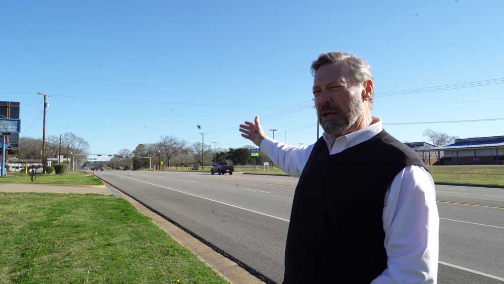
- Robert Wilson stands across the street from Kissam Elementary School in Chapel Hill.
A group of Chapel Hill residents are voicing concern over how close a proposed Toll 49 extension would be to schools and the methodology being used by the toll authority.
“Save Kids from Loop 49” is trying to draw attention to how close the proposed Teal Route would be to Kissam Elementary School in Chapel Hill. Loop 49 is what the proposed roadway was originally called before it became a toll road.
NETRMA, or the Northeast Texas Regional Mobility Authority, has the route set to cross State Highway 64 East just 800 feet from the entrance of the school. It would come out just outside of a heavily trafficked school zone.
Robert Wilson said the area is densely populated, with the neighborhood he lives in just off of 64, and often has children walking home or running cross country. Wilson said they’re also concerned that Chapel Hill High School is just past Kissam, and would be putting teens who just got their licenses in a potentially dangerous situation with the minimum speed on the toll set at 65 miles per hour in most areas.
NETRMA Communications Director Colleen Colby said the routes will be studied further when an Environmental Impact Statement is conducted later this year.
“Several Chapel Hill ISD schools on SH 64 are nearby to the proposed Purple and Teal Adjusted routes,” Colby said. “While it is not uncommon to see schools near highway facilities like SH 64 and Toll 49 across the state, the study team will be taking the proximity of these facilities into account in the Environmental Impact Statement (EIS), which includes a Community Impact Assessment, air quality analysis, traffic noise study and public input. The NET RMA does not have a policy regarding the proximity of schools to a new roadway as the EIS process includes multiple ways to review and evaluate this concern.”
“From what we understand from (Texas Department of Transportation) guidance, there shouldn’t be a major highway within 1,000 feet of a school,” Wilson said. “This is 800 feet from the property line. The playground is much closer than that 800 feet.”
Wilson is also concerned that the feasibility survey did not list Cuddle Bugs Learning Center as a school. The center is directly across from Kissam and provides preschool, pre-K and after school programs, according to their website. Cuddle Bugs does not appear to be listed on the survey results. The Teal adjusted route shows 3 schools, which would include Kissam and Chapel Hill’s Middle and High School, which are linked by a bus loop. They’re also concerned about the Yellow and Purple routes running near Wise Elementary School and the East Texas Islamic Society, but those routes don’t cut in as close as the Teal.
The feasibility study shows that public preference scores for the other routes, which were adjusted had been averaged, but the Teal adjusted route public preference did not use a merged score.
“We think that consistent methodology alone would have ruled that out for consideration,” Wilson said.
Pink, Blue and Orange routes, which were further east had previously been ruled out.
“The public preference score for the adjusted routes was assumed to be the same as its corresponding original proposed route. For example, the Pink Adjusted route assumed the same public preference score as the Pink route. That was the same protocol for the Teal Adjusted and Blue Adjusted routes,” Colby said. “Combination routes were also developed following the public preference survey. Their route rankings were generated based on an average of the original routes that comprise the combined alignments. Yellow Adjusted was a combination route of Yellow and Purple and therefore followed this protocol.”
Of the remaining routes, the Teal would be the most expensive, at an estimated $345 million compared to $297 million for the Yellow Adjusted and $288 million for the Purple.
While the Teal route is listed in the survey has having the least dense population, it’s unclear how the area of Chapel Hill near the schools would rank on its own, as the Teal route would have a large portion in rural areas just east of Bascom Road. That rural area also means it ranks highest in number of creek crossings.
Wilson’s son has property that overlooks the area off of Bascom and said that while the safety of children is their primary concern, they also are worried about the impact the road would have if it crossed those creeks so close to Lake Tyler.
Previous routes were eliminated after community pushback because they were so close to the lake.
Wilson said they had attempted to address the concerns with methodology and distance from schools during a public input meeting last October, but it did not appear the study had accounted for the issues they raised. Colby said the EIS would delve deeper into the potential environmental impact.
NETRMA has not yet set a date for additional public input meetings.
“The community is encouraged to stay engaged, ask questions, and to attend future public meetings. We anticipate holding the next Toll 49, Segment 6 public meeting in spring 2020,” Colby said. “Additional meetings will be held during the EIS process. We welcome the community to sign up for updates on the project webpage. In addition, we are happy to provide a presentation to any business, organization, or neighborhood as requested. Contact us to set something up.”


-
eEdition
-
-
