Survey: Downburst winds up to 100 mph hit Whitehouse during fatal storm
Published 4:48 pm Friday, April 8, 2022
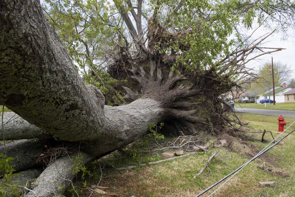
- Tree damage outside a home in Whitehouse.
Downburst winds estimated as powerful as 100 mph hit the city of Whitehouse in a fatal overnight storm earlier this week, according to a preliminary report for the National Weather Service of Shreveport.
The report is the result of a NWS team’s visit to Whitehouse on Tuesday to survey effects from the storm that left one man dead and caused significant damage to at least a dozen homes in the southern and eastern portions of the city.
The NWS report shows the winds came shortly after 1:30 a.m. Tuesday, resulting in numerous trees being snapped and uprooted along the storm’s path.
The majority of significant damage occurred in an east-southeasterly direction, NWS states, in a 2.75-mile radius.
The path began in the Willows subdivision just west of Willingham Road, where several small trees were snapped and small areas of shingles were ripped from roofs of a few homes with winds ranging from 70 to 75 mph, according to NWS.
The winds from the downburst intensified as it crossed Willingham Road, affecting several streets along and to the west of Highway 110 where numerous trees and large limbs were snapped and uprooted with 90 to 95 mph winds.
The most powerful winds reached speeds of 100 mph in the area of the Whitehouse Mobile Home and RV Park, where multiple trees were uprooted and 71-year-old W.M. Solomon was killed. The NWS reported a large pine fell on Solomon’s RV on Barbara Drive as he slept inside.
According to Whitehouse Fire Chief Madison Johnson, an official cause of death has not yet been determined.
The storm’s path continued along Hagan Road and Railroad Avenue before weakening as it entered the Waterton subdivision on East Main Street.
“It should be noted that wind damage was noted across much of Smith County and East Texas from these severe thunderstorms,” the NWS report states. “Many thanks to the Smith County Emergency Management and the Whitehouse Fire Department for their assistance in locating the more significant damage for this survey.”
According to the NWS, downbursts are powerful winds that originate from a thunderstorm and spread out quickly once they hit the ground.
“These winds can easily cause damage similar to that of a EF0 (65-85mph winds) or even EF1 (86-110mph winds) tornado, and are sometimes misinterpreted as tornadoes,” NWS states on its website. “However, downbursts are a completely separate phenomenon, and are a common area of study by meteorologists.”
The NWS preliminary report is subject to change pending final review of the event and publication in NWS storm data.
NWS predicts more severe weather; dry conditions increased wildfire risk
An extended period of severe weather is possible late Monday through Wednesday of next week, NWS said.
“During this period, strong damaging wind gusts, large hail and a tornado threat will be possible,” the NWS said in a hazardous weather outlook. “In addition to the severe weather threat, excessive heavy rainfall could result in a prolonged flood threat as well as across portions of the Four State Region.”
Meteorologist Brandon Thorne said in a Thursday weather briefing, East Texas would be under a “slight” risk of severe weather Monday, Tuesday and Wednesday as a cold front pushes through the area.
Thorne said the forecast and outlook on severe weather would be updated as the front gets closer.
Thorne also said the extended rainfall is expected to help drought conditions, which exist across much of the region.
According to Texas A&M Forest Service, East Texas fire resources received an average of one call every 14 minutes Thursday for assistance on a new wildfire. On Thursday, Texas A&M Forest Service and TIFMAS firefighters responded to at least 30 new ignitions for East Texas.
Wildfire activity is expected to increase through the weekend as more areas across the state will be characterized by dry to extremely dry surface fuels.
Additionally, timber litter fuels in East and Central Texas will likely become more receptive to burning through Saturday and support increased wildfire activity.
“Although we have seen some improvement to our drought conditions, we’re still expecting those to continue throughout the next little while,” Thorne said. “The rain that we get on Monday, Tuesday and Wednesday could bring some relief to that.”
Above normal wildfire activity has been the norm since December 2021. The frequency of significant wildfires has increased in parts of West Texas and South Texas since mid-March, as periods of critical to extreme fire weather occurred over regions experiencing severe to exceptional drought.
“The potential for large, significant wildfires across West Texas and South Texas will remain through early May,” said Wes Moorehead, Texas A&M Forest Service Fire Chief. “It is essential that Texans prepare for continued wildfire activity and to help prevent new ignitions.”
Nine out of 10 wildfires in Texas are human caused. Texas A&M Forest Service encourages the public to avoid outdoor activities that cause a spark while warm, dry and windy conditions are present.
“During these critical fire weather conditions, it is extremely important to remain mindful of all outdoor activities,” said Karen Stafford, Texas A&M Forest Service Prevention Program Coordinator. “Any activity that can create a spark, can start a wildfire.”


-
eEdition
-
-
