East Texas under ‘enhanced’ risk of severe weather today
Published 10:06 am Monday, January 2, 2023
- small1-8.png
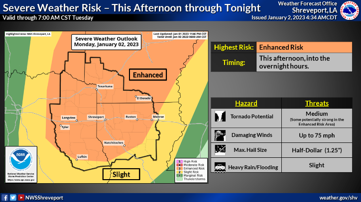
The National Weather Service says strong to severe thunderstorms are expected to develop across much of the East Texas region this afternoon through tonight.
“All modes of severe weather will be possible over the next 24 hours, including tornadoes,” the NWS said in a hazardous weather outlook issued Monday morning. “The tornado threat will come in both the traditional Supercell form, and eventually the QLCS form. Given the strongly sheared environment, a few of these tornadoes could be strong. Heavy rain and isolated flash flooding may also become a concern, but that is more likely in the portions of our area under a Flood Watch.”
The eastern parts of the region are also under a flood watch from noon Monday through late Monday, including Panola and Harrison counties.
“Excessive runoff may result in flooding of rivers, creeks, streams, and other low-lying and flood-prone locations,” the NWS said. “Creeks and streams may rise out of their banks…
“Scattered to numerous showers and thunderstorms, some of which will contain heavy rainfall, are expected to develop this afternoon and tonight across the region. Grounds remain saturated in wake of heavy rainfall that fell late last week across much of the Watch area, with additional rainfall amounts of 1 to 2 inches expected with isolated higher amounts in excess of 3 inches possible.”


-
eEdition
-
-
