Experts urge preparation as snow, ice expected to accumulate in East Texas
Published 8:00 am Wednesday, January 8, 2025
- Ggusx-hWIAAtAfl.jpg
Weather experts say the time to prepare for winter precipitation is now, as snow and ice accumulation are predicted in East Texas by Thursday night.
A winter storm warning is in effect from 6 a.m. Thursday to noon Friday for most of northern East Texas, including Smith County, as heavy mixed winter precipitation is possible.
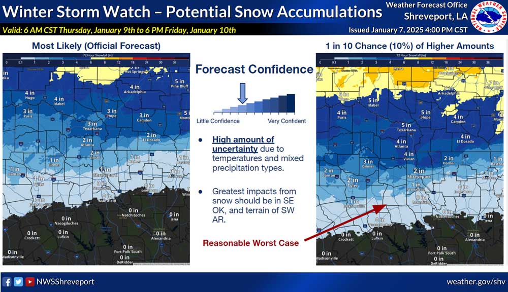
The NWS says total snow accumulations between 2 and 6 inches, as well as ice accumulations up to half an inch, are possible beginning Thursday morning. The most recent forecast shows Tyler is most likely to receive only about an inch of snow, but there is a high amount of uncertainty due to temperatures and mixed precipitation types.
“Roads, and especially bridges and overpasses, will likely become slick and hazardous,” NWS said. “Power outages and tree damage are likely due to the ice. Travel could be nearly impossible. The hazardous conditions could impact the Thursday morning and evening commutes.”
Smith, Wood, Upshur and Gregg counties are among those affected.
Temperatures are expected to be in the mid-20s Wednesday night with a high of about 43 Wednesday. Thursday, the low will be around 27 with a high of 37 in Tyler, and Friday will see a low temperature of about 33 and a high of 40.
In Tyler on Tuesday, residents were making preparations by buying firewood, preparing their generators, dripping faucets, and making sure they had ways to receive weather alerts.
As the wintry mix gets ready to fall, NWS advises the following preparations:
NOW — Have emergency supplies for your home and car; Check some and carbon monoxide detectors; Replenish fuel for car and heating sources
DAY BEFORE — Adjust plans; Have multiple ways to receive warnings; Bring pets indoors and ensure they have water
DURING AND AFTER — Check on neighbors and family; Properly ventilate emergency heat sources; Keep generators at least 20 feet from your home; Take it easy when shoveling.
There is no watch or warning in effect for Rusk, Panola, Henderson, Anderson or Cherokee counties, although the NWS is forecasting some amount of winter precipitation for those areas through Friday.
Snow and ice accumulation is expected to start around 6 a.m. Thursday in the northwestern part of the region, moving south and east through Friday.
Areas north of Interstate 30 are expected to see the most snow, with parts of Northeast Texas seeing between 4 and 6 inches, areas along I-20, including the Smith County, area, expected to see 1 to 2 inches. Areas south of I-20 may receive less than an inch of snow.
Areas along the I-20 corridor are forecasted to see between a quarter and a half inch of ice, while areas around I-30 and south of I-20 will see between 0.1 and 0.25 inches of ice.
City of Tyler officials are monitoring the weather situation and strongly advise residents to watch the weather forecast, winterize their homes and safely use space heaters and generators.
The city says emergency service capabilities are at full strength, and city departments are in frequent communication with each other to ensure all necessary preparations are in place.
The city advises residents to call 9-1-1 in an emergency and stay on the line, don’t hang up until the call is answered. Answer all questions and follow instructions.
The Tyler Police Department’s non-emergency line (903) 531-1000 should be used for all other calls and notifications, including traffic signal issues.
How do I get alerts about storm updates or emergency information?
The City of Tyler has a free emergency alert system that you may sign up for through Smart 911 with RAVE Alert.
Signing up for alerts can be done online at www.smart911.com, where users can then be able to select which alerts from the City of Tyler, Smith County and surrounding areas you would like to receive.
Account users may sign up to receive email and text message alerts. In addition, users may opt to provide additional information like medical conditions, pet information, house description and more. This gives first responders access to critical information on how best to respond to your family’s needs in an emergency situation. All information is secure and will not be shared publicly.
There is also an app available for download for both Apple and Android users.
Utilities/Water Pipes
All essential city services, including water and wastewater, will continue to operate at full capacity.
Turn sprinkler systems off. Sprinkler systems left on when temperatures drop below freezing may cause sheets of ice to form in streets and on sidewalks. This can create hazardous driving conditions and dangerous walking conditions on both sidewalks and crosswalks.
Frigid temperatures can cause water lines to burst, leading to expensive plumbing repairs.
Remove hoses from outside faucets. Insulate outdoor faucets with a commercial Styrofoam cover, towels, rags or paper.
Know where the main water valve is located at your residence and how to turn it off.
Cover or insulate exposed pipes outside or in unheated areas of your home.
Let cold and hot water drip from faucets at a trickle.
Open kitchen and bathroom sink cabinet doors to circulate warmer air around plumbing.
The Tyler Building Department reminds residents to use only qualified registered plumbers to fix any broken pipe issues. Licensed plumbers are urged to make repairs needed to get customers’ plumbing back in operation and to contact the Permitting Office as soon as possible.
Be a good neighbor
The City of Tyler reminds residents to be good neighbors, work together to take care of people in the community and help each other. Connect with family members, friends, social groups, and work circles for assistance and support.
Check on elderly family members, neighbors, and friends. Older adults can lose body heat fast, and some illnesses may make it harder to stay warm.
Pets
Tyler Animal Control and Shelter reminds pet owners to bring their pets inside where it is warm or set up proper shelter for the animal.
Plants
Cover vulnerable plants and flowers with blankets or sheets.
Roads
Although snow is not predicted, even small accumulations of ice can be extremely dangerous to motorists and pedestrians. Bridges and overpasses are particularly hazardous because they freeze before other surfaces.
Black ice
Black ice is a deadly driving hazard defined as patchy ice on roadways or other transportation surfaces that cannot easily be seen. It is often clear (not white), with the black road surface visible underneath. It is most prevalent during the early morning hours, especially after snow melt on the roadways has a chance to refreeze overnight when the temperature drops below freezing. Black ice can also form when roadways are slick from rain and temperatures drop below freezing overnight.


-
eEdition
-
-
