Heavy rain possible, but Tropical Storm Francine expected to bypass East Texas
Published 4:15 pm Monday, September 9, 2024
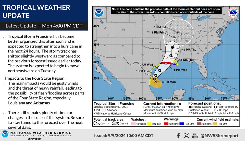
- Tropical Storm Francine is not expected to cross directly over East Texas at this time, the NWS said. (NWS/Contributed Photo)
The National Weather Service in Shreveport team says they are watching a potential flood threat later for this week now that Tropical Storm Francine has formed in the Gulf of Mexico.
The storm’s path is not expected to cross directly over East Texas at this time, the NWS said.
Trending
“We will continue to monitor the system currently in the southwest Gulf of Mexico for possible impacts across portions of the Four State Region Wednesday into Thursday of this week,” the NWS said Monday morning with a storm outlook. “At this time, at the very least, heavy rainfall will be possible across portions of Deep East Texas into North Central and Northeast Louisiana.”
Tropical Storm Francine has developed over the southwestern Gulf of Mexico. As of Monday around 4 p.m., NWS said the storm has become “better organized” and is expected to strengthen into a hurricane in the next 24 hours.
The storm track has shifted slightly westward as compared to earlier forecasts. It is expected to move northeastward on Tuesday, according to NWS.
The NWS said, as for impacts to the East Texas region, current trends indicate gusty winds and the threat of heavy rainfall, leading to the possibility of flash flooding.
“There still remains plenty of time for changes in the track of this system,” NWS said Monday afternoon, noting residents should stay tuned to the forecast over the next several days.
Trending


-
eEdition
-
-
