NWS warns of wintry mix in East Texas; freezing rain, sleet expected
Published 4:00 pm Friday, January 12, 2024
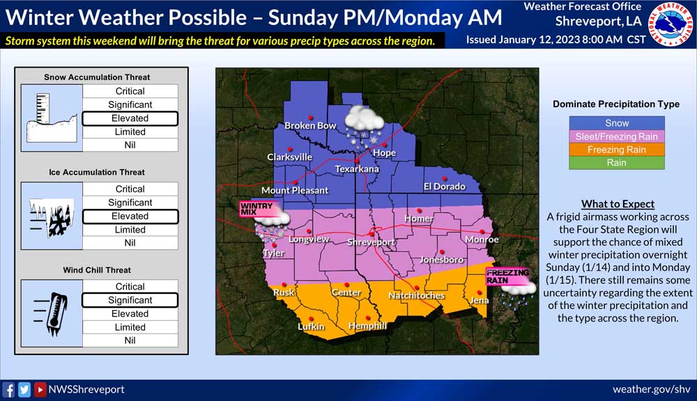
- GDrLsCzWwAAzVUK.jpg
Cold air is making its way across the region and headed to East Texas, the National Weather Service of Shreveport said.
Severe storms have left the region and attention turns to the threat of mixed winter precipitation late this weekend, NWS said.
Snow, sleet and freezing rain are all possible in East Texas.
Tyler and Smith County are predicted to receive sleet and freezing rain. The snow and ice accumulation threat is “elevated” and the wind chill threat is “significant,” according to NWS.
Rusk County will see freezing rain, while areas north of Smith County like Mount Pleasant could see snow.
A frigid airmass is working its way across the region and will support the chance of mixed winter precipitation overnight Sunday and into Monday.
“There still remains some uncertainty regarding the extent of the winter precipitation and the type across the region,” NWS said Friday morning.
Friday night’s temperature reached about 33, but things are warming up Saturday morning to a high of near 54. Temperatures will drop 10 degrees below freezing Saturday night with a low of 22. Sunday’s high is expected to be about 34 degrees with a low of 23 that night and a chance of wintry mix. The MLK Day forecast predicts a high of just 26 with a chance of sleet and freezing rain. The low will be around 13 degrees, according to NWS.
For the latest weather news, stay tuned with us and our trusted news partners and weather team at CBS19.


-
eEdition
-
-
