‘My Tyler’ app puts city services at residents’ fingertips
Published 6:05 pm Friday, May 27, 2016
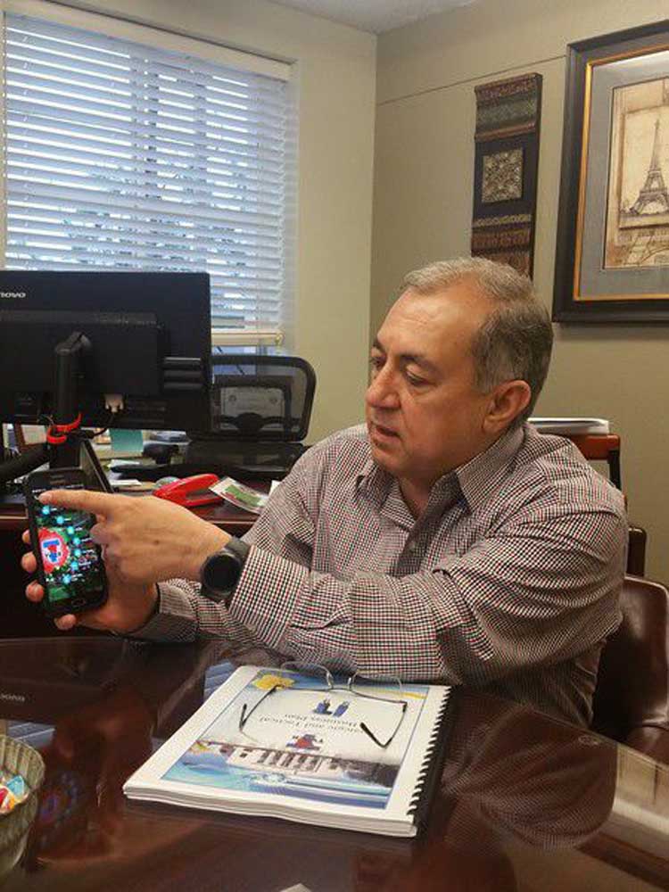
- Chief Information Officer Benny Yazdanpanahi illustrates how to use the new 'My Tyler' app on Friday. Faith Harper/Staff
Want to pay your water bill, report a pothole, check traffic or look at a zoning map – the city of Tyler has you covered.
There really is an app for everything.
Trending
This month, the city released a new, and free, “My Tyler” smartphone app that puts a list of city services in its residents’ hands.
The app opens to a colorful background of flowers in bloom at the Tyler Rose Garden and a scrolling wheel of commonly used options. More options are available with a quick swipe left.
“We are trying to put more and more of what resident’s needs are in their fingertips,” said Chief Information Officer Benny Yazdanpanahi. “The majority of our residents today are mobile people. They don’t sit in front of their computers to do stuff – especially Millennials. We want to reach out and say, ‘We are your government, and we are here for you.'”
Residents can check when their trash and recycling will be picked up, scroll through upcoming events, see what there is to eat and do downtown and view a list of most-commonly called city phone numbers.
“We invested tons of resources downtown for the half mile of history markers,” Yazdanpanahi said. “If you click on ‘half mile of history,’ it shows you all of them, and you can read about it. (Some of them) have video or audio.”
My Tyler also allows residents to look at the city’s public transit bus routes in real time. A bus icon moves with the route, showing where it is, and each stop is identified with designated pickup times.
Trending
Residents also can look through a list of annual events and search the city’s parks by location and amenities. Another feature will give the user turn-by-turn directions to the park.
The parks tab also includes a map of the city’s bike trails.
Swipe to the left, and an expanded blue tool bar pops up with a longer list of options.
From there, residents can check the status of their flight out of the Tyler Pounds Regional Airport, pay their water bill or change their water service.
They can search through the Tyler Public Library’s book offerings, apply for a job with the city and look at the code of ordinances.
A traffic map also helps residents pick the best route around town.
Yazdanpanahi said the idea started with trying to make an easier way for residents to report a pothole or graffiti and grew from there.
That ability was already available online, but it was limited.
“It would only send out an email,” he said. “It did not put out GPS coordinates, and it did not connect to our backend software to create a work order. The new app allows us to connect to the backend software to create a work order, and sends an email to the street department if they are off duty.”
Now, residents can add a photo.
The app actually connects into the base of the city’s network infrastructure – a program called SunGard that is used in multiple departments including police, fire, dispatch, the planning department and more.
SunGard allows the city’s various departments to share information within one system.
Yazdanpanahi said SunGard partnered with the California-based app developer, MyCivic Apps, to build My Tyler.
The project was a showpiece for the companies to market the app building services to other municipalities using SunGard’s software.
All the work was free for Tyler, Yazdanpanahi said.
The city also is looking for ideas on how to improve the app.
The goal is to make the app go beyond the city’s offerings and become a community app.
Twitter: @TMTFaith


-
eEdition
-
-
