East Texas under cold weather advisory through Sunday morning
Published 6:00 pm Saturday, January 18, 2025
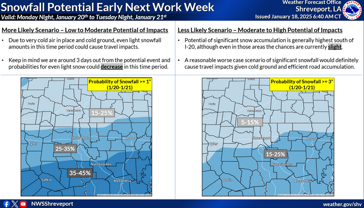
- The NWS is also monitoring potential snowfall Monday night and Tuesday. (Contributed Graphic)
Almost all of East Texas is under a cold weather advisory through Sunday morning, and the National Weather Service in Shreveport says confidence in wintry precipitation next week is increasing.
The cold weather advisory includes the following Texas counties: Red River, Bowie, Franklin, Titus, Camp, Morris, Cass, Wood, Upshur, Marion, Smith, Gregg, Harrison, Cherokee, Rusk, Panola, Nacogdoches, Shelby, Angelina, San Augustine and Sabine.
Trending
It runs from midnight tonight to 8 a.m. Sunday. Very cold wind chills around 10 degrees are expected across the Interstate 30 corridor. Wind chills as low as 10 to 15 degrees are expected across portions of the I-20 corridor and south.
“Use caution while traveling outside. Wear appropriate clothing, a hat, and gloves,” the NWS said. “Keep pets indoors as much as possible. Make frequent checks on older family, friends, and neighbors. Ensure portable heaters are used correctly. Do not use generators or grills inside.”
The NWS is also monitoring potential snowfall Monday night and Tuesday, saying “Although chances remain below 50 percent, confidence has increased over the past 24 hours for wintry precipitation, especially south of I-20 corridor. Lots of uncertainty still remain, so continue monitor the forecast for updates.”
Due to very cold arctic air in place and a cold ground, the NWS says even light snowfall amounts in this time period could cause travel impacts.
Probabilities for the “more likely” scenario of about an inch of snow include a 15 to 25% chance in northern areas of East Texas, 25 to 33% chance for the I-20 corridor and 35 to 45% chance for a line from southern Cherokee County to Shelby County.
Probabilities for a “less likely” scenario of around 3 inches of snow are 5 to 15% above and 15 to 25% below a line stretching from northern Cherokee County, northern Rusk County and northern Panola County.
Trending
But the NWS says the forecast could change.
“Keep in mind we are around 3 days out from the potential event and probabilities for even light snow could decrease in this time period,” the NWS said.


-
eEdition
-
-
